Here you’ll find the Executive Summary of studies done pertaining to the EnergyPlex Park. For more details on specific sections, download the full Executive Summary or visit pages linked within sections for more in-depth details.
Download Executive Summary
Cultural Resource Study
No indicators, such as aeolian (blow sand) sand dunes, abundant shinnery oak, or abundant mesquite are in the project area. There is some evidence of pre-1964 homesteading in section 5 of T18S, R37E including a small family cemetary. For more information, see
Fatal Flaw and Reconnaissance Cultural Resource Survey.
Reconnaissance Biological Study
EnergyPlex Park is home to several species of plants and animals. None of the plants found are considered rare or protected. The Park is home to some 26 species of birds, 8 species of mammals, and 2 species of reptiles. Most species of birds fall under the Migratory Bird Treaty Act. Recommendations include scheduling land clearing outside of traditional breeding season. For more information, download entire Executive Summary.
Phase 1 Environmental Site Assessment
EnergyPlex Park is located primarily on former agricultural land. In the past, it has been used as rangeland as well as limited oil and gas development. There are no indications of anything prohibiting development. For full details, see Phase 1 Environmental Study.
Soils and Minerals
Much of the surface of the High Plains is underlain by aeolian and alluvial deposits of the Ogallala Formation and has a resistant caliche caprock. For more information, download entire Executive Summary.
The Park and the Hobbs, NM area has primarily sedimentary deposits and is located north east of the Mescalero Ridge, which is the western escarpment of the Southern High Plains. There are no quaternary faults or folds in southeast New Mexico/West Texas. For more details, download entire Executive Summary.
Air Quality/Wetlands
There are no major pollutants in Lea County and EnergyPlex Park has no wetlands.
Climate/Weather
Lea County has a semi-arid climate with warm summers and cool, dry winters. Average rainfall is 14.6 inches, occuring usually May through October.
Infrastructure/Utilities
EnergyPlex Park can be accessed through several roadways including NM 483 and access to NM 18 is planned to connect the two across the park. A two-mile rail spur is planned to connect the Park to the Texas and New Mexico Railway shortline which connects to the Union Pacific in Texas. Utilities to the site may include water, sewer, electric, fiber optic, and natural gas. For more information on utilites, please see Existing Infrastructure.
Demographic information
| Eunice | Hobbs | Jal | Lovington | Tatum | Lea County | |
|---|---|---|---|---|---|---|
| Total Population | 3,210 | 44,044 | 2,179 | 15,059 | 1,189 | 68,062 |
| Female Population | 1,511 | 21,330 | 1,077 | 7,425 | 584 | 35,027 |
| Male Population | 1,699 | 22,714 | 1,102 | 7,634 | 605 | 33,035 |
| Total Households | 1,438 | 16,564 | 1,013 | 5,244 | 649 | 24,898 |
| Median Age | 37 | 32 | 41 | 29 | 40 | 32 |
For more demographics, see Demographics.
Drainage Study
Approximately 100 acres are designated Zone AO according to the Federal Emergency Management Agency Flood Insurance Rate Map. The rest of the property is designated Zone X. For more information, see Drainage Study.
Below, you’ll find potential plans for EnergyPlex Park, including transportation and utilities. For full details, download the Planning Report. For more information on existing infrastructure, see Existing Infrastructure.
Download Planning Report
Transportation:
Roadways: There are several major roads adjacent to EnergyPlex Park including NM 18 and NM 483, as well as US 62/180 and NM 8. There are several options for these roads, and others, to be connected to the Park. There are currently several dirt and caliche roads that lead into the park for access. The map below shows possible road extensions within the Park.
Railway: The Texas-New Mexico Railroad (TNMR) shortline lies adjacent to the Park. A branch extension would give direct rail access within the Park. The map below shows possible transportation extensions within EnergyPlex Park. For more details, download the full Planning Report.
Utilities
Water Service: EnergyPlex Park currently has an existing water well, and an 8″ pipeline lies within the site. The Park is close to several other water sources that could be extended into the Park including City of Hobbs water lines in several locations and well fields from the Hobbs Industrial Airpark nearby. For more information, see the map below for possible water extensions within EnergyPlex Park.
Sanitary Sewer Service: The City of Hobbs currently has a 10″ sewer line running east of EnergyPlex Park, but not within the site. An option may be to extend this sewer line. The Park may be better served by having its own waste water reclamation facility depending on waste water needs. The map below shows possible sewer extensions within the Park.
Power: Electrical power to EnergyPlex Park is provided by Xcel Energy with two transmission lines (115 kV and 230 kV) crossing the site from the Maddox and Cunningham stations. New distribution lines and substations may be constructed to provide additional power to the park. See the map below for possible power extensions.
Fiber Optic Service: There are several options to bring fiber optic to EnergyPlex Park including an extension from existing Windstream fiber-fed lines to the south or Leaco’s existing fiber lines to the east of NM 18. See the map below for possible extensions.
Natural Gas Service: The Park can be serviced by both New Mexico Gas Company and Zia Natural Gas Company depending on the Township location. Zia has an existing 4″ pipeline in the south east corner of the Park. On the north side, an extension could connect the Park to an existing 6″ line from NM Gas Company. See the map below for possible extensions.
Below, find information regarding EnergyPlex Park’s existing infractructure. For more details, download the entire report.
Download Existing Infrastructure Capacity Analysis
Transportation:
Roads:
EnergyPlex Park is conveniently located between several major roadways in Lea County, including NM 18 which connects Lovington and Hobbs as well as has access to US 62/180; NM 483, a Hobbs bypass that connects US 62/180 to Lovington as well as provides a connection to US 82, a route to Artesia; and US 62/180 which runs through southern New Mexico and into Texas, from El Paso, TX to Carlsbad, NM through Hobbs and on to Seminole and Lubbock, TX.
Annual Average Daily Traffic Counts
2013 | 2012 | 2011 | |
NM 18 | 9,665 | 9,713 | 9,619 |
NM 483 | 1,207 | 1,220 | 1,215 |
US 62/180 | 6,107 | 6,130 | 6,113 |
US 82 | 4,601 | 4,648 | 4,647 |
Source: New Mexico Department of Transportation
Airports:
Lea County Regional Airport is located within 10 minutes of the Park and provides three active asphalt runways. Pavement strength loadings are 65,000 for a single wheel loading and 100,000 for double wheel loading. For more specific capacity information, see full report above. The Regional Airport is also served by United Airlines, providing daily flights direct from Hobbs to Houston for passenger travel. EnergyPlex Park is also located nearby to the Hobbs Industrial Air Park as well as Lea County-Zip Franklin Memorial Airport.
In addition, Lea County is located within 90-100 minutes of two international airports: Lubbock and Midland.
Rail:
EnergyPlex Park is located 1.2 miles from the Texas and New Mexico Railway shortline (TNX) which connects to Union Pacific in Monahans, TX to Lovington, NM. The railroad has a current capacity of 286,000 pounds per axle and car storage of 500 fifty-foot cars.
To Continue Reading Click Here
There are few cultural resources within the EnergyPlex Park area and no significant issues preventing development.
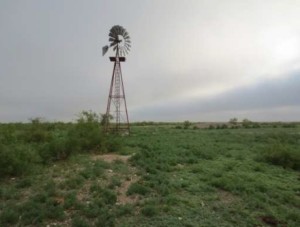
Some historical resources may be present relating to homesteading, farming and ranching. Those worthy of note include an irrigation ditch, windmills, pre-1964 oil industry features, houses/outbuildings, stock tanks, and stock ponds. A small cemetary should also be noted and avoided.
The Park also has a few playas which may have held water in prehistoric times. It is unknown whether the playas have any cultural resources.
For a fully detailed report on cultural resources, download the full report below.
Download Fatal Flaw and Reconnaissance Cultural Survey
Download Biological Resources Reconnaissance Survey
There are no significant issues preventing development in EnergyPlex Park.
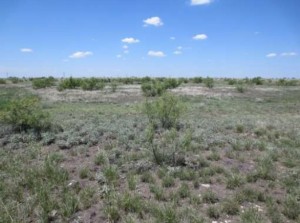
Vegetation:
Most of EnergyPlex Park sits on a caprock base with little variation in elevation. Much of the Park is covered in grasses of various types. None of the Park can be classified as a wetland. There is also some mesquite, snake weed, and other plants within the Park area. There are no noxious weed species found within the site.
Wildlife:
Thirty-six species of animals have been identified as living in the Park area, including birds, mammals, and reptiles. There are at least six species of birds of prey, including hawks and owls. The mammals are largely prairie dogs with some evidence of coyotes. Some of these birds may fall under the Migratory Bird Treaty Act which could necessitate removal of nests during construction if construction occurs during the nesting period.
There are several Western Burrowing Owls within the Park area and the species may need special attention during construction period. However, all of the owl nests observed were located with prairie dog burrows.
Download Phase 1 Environmental Report
EnergyPlex Park is located on nearly 9,600 acres, situated between Hobbs and Lovington. There are no significant issues preventing development.
The land has been previously used primarily for agriculture and range land with some oil usage as well. The land itself is categorized as “level and dry” with normal grade elevation and drainage. The soil is mainly composed of Kimbrough soil, which is a source for caliche. Other soils located in the area include Stegall and Slaughter soil and Portales-Stegall loams.
There are several wells on the property, many abandoned but some still in use. Otherwise, there is an abandoned homestead with two pole barns and a windmill erected.
There were no indications to prohibit development on the site. For more details, see full report.

Download Drainage/Flood Plain Study and Mapping
EnergyPlex Park has been designated as a Zone X, which is categorized as a moderate to low flood risk, outside of the 500-year flood plain and protected by levee from 100-year floods. It is recommended that building construction be at least 18″ higher than the 100-year flood water surface elevation at the nearest cross section. At this location, the rainfall for a 100-year, 6-hour storm and a 25-year, 6-hour storm was determined to be 5.30 and 4.03 inches respectively. For full details, download the complete study.
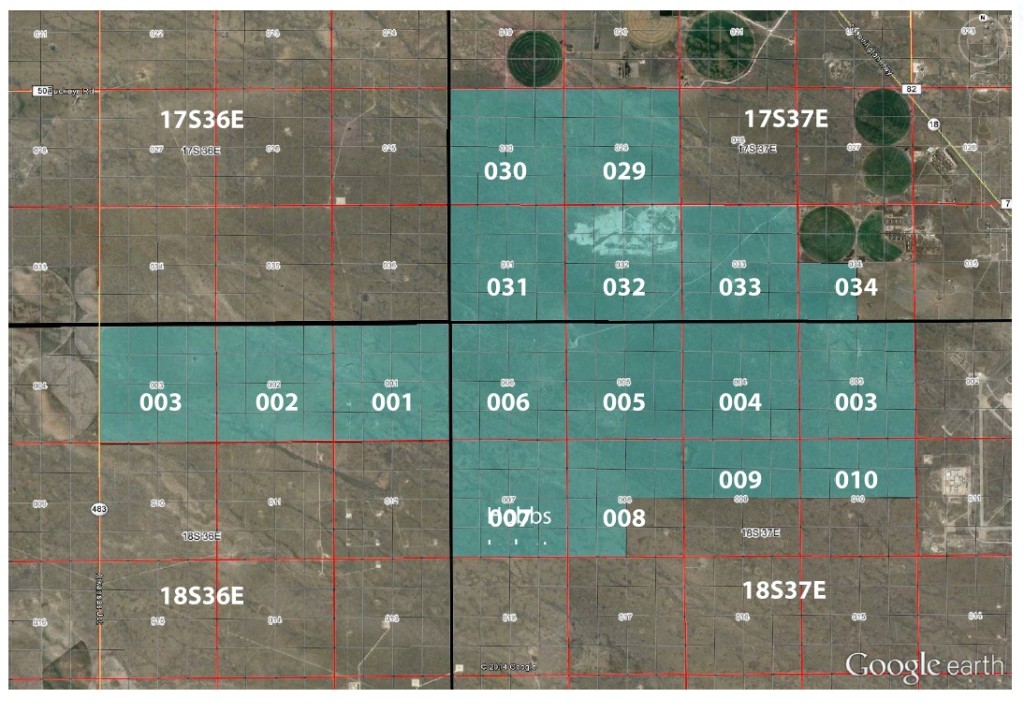
Click below to expand sections and view topographical photos of each panel. Reference numbers for panels:

Click below to expand sections and view topographical photos of each panel. Reference numbers for panels:
[trx_toggles style=”1″ counter=”off” large=”off”] [trx_toggles_item title=”Section 1″ open=”no”]
1. T 18S R 36E NE/NE
2. T 18S R 36E NW/NE
3. T 18S R 36E NE/NW
4 T 18S R 36E NW/NW
5. T 18S R 36E SW/NW
6. T 18S R 36E SE/NW
7. T 18S R 36E SW/NE
8. T 18S R 36E SE/NE
9. T 18S R 36E NE/SE
10. T 18S R 36E NW/SE
11. T 18S R 36E NE/SW
12. T 18S R 36E NW/SW
13. T 18S R 36E SW/SW
14. T 18S R 36E SE/SW
15. T 18S R 36E SW/SE
16. T 18S R 36E SE/SE
[/trx_toggles_item] [trx_toggles_item title=”Section 2″ open=”no”]
1. T 18S R 36E NE/NE
2. T 18S R 36E NW/NE
3. T 18S R 36E NE/NW
4. T 18S R 36E NW/NW
5. T 18S R 36E SW/NW
6. T 18S R 36E SE/NW
7. T 18S R 36E SW/NE
8. T 18S R 36E SE/NE
9. T 18S R 36E NE/SE
10. T 18S R 36E NW/SE
11. T 18S R 36E NE/SW
12. T 18S R 36E NW/SW
13. T 18S R 36E SW/SW
14. T 18S R 36E SE/SW
15. T 18S R 36E SW/SE
16. T 18S R 36E SE/SE
[/trx_toggles_item] [trx_toggles_item title=”Section 3 (36E)” open=”no”]
1. T 18S R 36E NE/NE
2. T 18S R 36E NW/NE
3. T 18S R 36E NE/NW
4. T 18S R 36E NW/NW
5. T 18S R 36E SW/NW
6. T 18S R 36E SE/NW
7. T 18S R 36E SW/NE
8. T 18S R 36E SE/NE
9. T 18S R 36E NE/SE
10. T 18S R 36E NW/SE
11. T 18S R 36E NE/SW
12. T 18S R 36E NW/SW
13. T 18S R 36E SW/SW
14. T 18S R 36E SE/SW
15. T 18S R 36E SW/SE
16. T 18S R 36E SE/SE
[/trx_toggles_item] [trx_toggles_item title=”Section 3 (37E)” open=”no”]
1. T 18S R 37E NE/NE
2. T 18S R 37E NW/NE
3. T 18S R 37E NE/NW
4. T 18S R 37E NW/NW
5. T 18S R 37E SW/NW
6. T 18S R 37E SE/NW
7. T 18S R 37E SW/NE
8. T 18S R 37E SE/NE
9. T 18S R 37E NE/SE
10. T 18S R 37E NW/SE
11. T 18S R 37E NE/SW
12. T 18S R 37E NW/SW
13. T 18S R 37E SW/SW
14. T 18S R 37E SE/SW
15. T 18S R 37E SW/SE
16. T 18S R 37E SE/SE
[/trx_toggles_item] [trx_toggles_item title=”Section 4″ open=”no”]
1. T 18S R 37E NE/NE
2. T 18S R 37E NW/NE
3. T 18S R 37E NE/NW
4. T 18S R 37E NW/NW
5. T 18S R 37E SW/NW
6. T 18S R 37E SE/NW
7. T 18S R 37E SW/NE
8. T 18S R 37E SE/NE
9. T 18S R 37E NE/SE
10. T 18S R 37E NW/SE
11. T 18S R 37E NE/SW
12. T 18S R 37E NW/SW
13. T 18S R 37E SW/SW
14. T 18S R 37E SE/SW
15. T 18S R 37E SW/SE
16. T 18S R 37E SE/SE
[/trx_toggles_item] [trx_toggles_item title=”Section 5″ open=”no”]
1. T 18S R 37E NE/NE
2. T 18S R 37E NW/NE
3. T 18S R 37E NE/NW
4. T 18S R 37E NW/NW
5. T 18S R 37E SW/NW
6. T 18S R 37E SE/NW
7. T 18S R 37E SW/NE
8. T 18S R 37E SE/NE
9. T 18S R 37E NE/SE
10. T 18S R 37E NW/SE
11. T 18S R 37E NE/SW
12. T 18S R 37E NW/SW
13. T 18S R 37E SW/SW
14. T 18S R 37E SE/SW
15. T 18S R 37E SW/SE
16. T 18S R 37E SE/SE
[/trx_toggles_item] [trx_toggles_item title=”Section 6″ open=”no”]
1. T 18S R 37E NE/NE
2. T 18S R 37E NW/NE
3. T 18S R 37E NE/NW
4. T 18S R 37E NW/NW
5. T 18S R 37E SW/NW
6. T 18S R 37E SE/NW
7. T 18S R 37E SW/NE
8. T 18S R 37E SE/NE
9. T 18S R 37E NE/SE
10. T 18S R 37E NW/SE
11. T 18S R 37E NE/SW
12. T 18S R 37E NW/SW
13. T 18S R 37E SW/SW
14. T 18S R 37E SE/SW
15. T 18S R 37E SW/SE
16. T 18S R 37E SE/SE
[/trx_toggles_item] [trx_toggles_item title=”Section 7″ open=”no”]
1. T 18S R 37E NE/NE
2. T 18S R 37E NW/NE
3. T 18S R 37E NE/NW
4. T 18S R 37E NW/NW
5. T 18S R 37E SW/NW
6. T 18S R 37E SE/NW
7. T 18S R 37E SW/NE
8. T 18S R 37E SE/NE
9. T 18S R 37E NE/SE
10. T 18S R 37E NW/SE
11. T 18S R 37E NE/SW
12. T 18S R 37E NW/SW
13. T 18S R 37E SW/SW
14. T 18S R 37E SE/SW
15. T 18S R 37E SW/SE
16. T 18S R 37E SE/SE
[/trx_toggles_item] [trx_toggles_item title=”Section 8 ” open=”no”]
1. T 18S R 37E NE/NE
2. T 18S R 37E NW/NE
3. T 18S R 37E NE/NW
4. T 18S R 37E NW/NW
5. T 18S R 37E SW/NW
6. T 18S R 37E SE/NW
7. T 18S R 37E SW/NE
8. T 18S R 37E SE/NE
11. T 18S R 37E NE/SW
12. T 18S R 37E NW/SW
13. T 18S R 37E SW/SW
14. T 18S R 37E SE/SW
[/trx_toggles_item] [trx_toggles_item title=”Section 9″ open=”no”]
1. T 18S R 37E NE/NE
2. T 18S R 37E NW/NE
3. T 18S R 37E NE/NW
4. T 18S R 37E NW/NW
5. T 18S R 37E SW/NW
6. T 18S R 37E SE/NW
7. T 18S R 37E SW/NE
8. T 18S R 37E SE/NE
[/trx_toggles_item] [trx_toggles_item title=”Section 10″ open=”no”]
1. T 18S R 37E NE/NE
2. T 18S R 37E NW/NE
3. T 18S R 37E NE/NW
4. T 18S R 37E NW/NW
5. T 18S R 37E SW/NW
6. T 18S R 37E SE/NW
7. T 18S R 37E SW/NE
8. T 18S R 37E SE/NE
[/trx_toggles_item] [trx_toggles_item title=”Section 29″ open=”no”]
1. T 18S R 37E NE/NE
2. T 17S R 37E NW/NE
3. T 17S R 37E NE/NW
4. T 17S R 37E NW/NW
5. T 17S R 37E SW/NW
6. T 17S R 37E SE/NW
7. T 17S R 37E SW/NE
8. T 17S R 37E SE/NE
9. T 17S R 37E NE/SE
10. T 17S R 37E NW/SE
11. T 17S R 37E NE/SW
12. T 17S R 37E NW/SW
13. T 17S R 37E SW/SW
14. T 17S R 37E SE/SW
15. T 17S R 37E SW/SE
16. T 17S R 37E SE/SE
[/trx_toggles_item] [trx_toggles_item title=”Section 30″ open=”no”]
1. T 18S R 37E NE/NE2.
2. T 17S R 37E NW/NE
3. T 17S R 37E NE/NW
4. T 17S R 37E NW/NW
5. T 17S R 37E SW/NW
6. T 17S R 37E SE/NW
7. T 17S R 37E SW/NE
8. T 17S R 37E SE/NE
90. T 17S R 37E NE/SE
10. T 17S R 37E NW/SE
11. T 17S R 37E NE/SW
12. T 17S R 37E NW/SW
13. T 17S R 37E SW/SW
14. T 17S R 37E SE/SW
15. T 17S R 37E SW/SE
16. T 17S R 37E SE/SE
[/trx_toggles_item] [trx_toggles_item title=”Section 31″ open=”no”]
1. T 18S R 37E NE/NE
2. T 17S R 37E NW/NE
3. T 17S R 37E NE/NW
4. T 17S R 37E NW/NW
5. T 17S R 37E SW/NW
6. T 17S R 37E SE/NW
7. T 17S R 37E SW/NE
8. T 17S R 37E SE/NE
9. T 17S R 37E NE/SE
10. T 17S R 37E NW/SE
11. T 17S R 37E NE/SW
12. T 17S R 37E NW/SW
13. T 17S R 37E SW/SW
14. T 17S R 37E SE/SW
15. T 17S R 37E SW/SE
16. T 17S R 37E SE/SE
[/trx_toggles_item] [trx_toggles_item title=”Section 32″ open=”no”]
1. T 18S R 37E NE/NE
2. T 17S R 37E NW/NE
3. T 17S R 37E NE/NW
4. T 17S R 37E NW/NW
5. T 17S R 37E SW/NW
6. T 17S R 37E SE/NW
7. T 17S R 37E SW/NE
8. T 17S R 37E SE/NE
9. T 17S R 37E NE/SE
10. T 17S R 37E NW/SE
11. T 17S R 37E NE/SW
12. T 17S R 37E NW/SW
13. T 17S R 37E SW/SW
14. T 17S R 37E SE/SW
15. T 17S R 37E SW/SE
16. T 17S R 37E SE/SE
[/trx_toggles_item] [trx_toggles_item title=”Section 33″ open=”no”]
1. T 18S R 37E NE/NE
2. T 17S R 37E NW/NE
3. T 17S R 37E NE/NW
4. T 17S R 37E NW/NW
5. T 17S R 37E SW/NW
6. T 17S R 37E SE/NW
7. T 17S R 37E SW/NE
8. T 17S R 37E SE/NE
9. T 17S R 37E NE/SE
10. T 17S R 37E NW/SE
11. T 17S R 37E NE/SW
12. T 17S R 37E NW/SW
13. T 17S R 37E SW/SW
14. T 17S R 37E SE/SW
15. T 17S R 37E SW/SE
16. T 17S R 37E SE/SE
[/trx_toggles_item] [trx_toggles_item title=”Section 34″ open=”no”]
11. T 17S R 37E NE/SW
12. T 17S R 37E NW/SW
13. T 17S R 37E SW/SW
14. T 17S R 37E SE/SW
[/trx_toggles_item] [/trx_toggles]